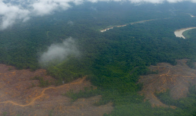
AsianScientist (Dec. 3, 2015) – By Natalie Heng – Malaysia now remains the only country that has yet to resolve its legal position on supplying concession site boundary maps for oil palm plantations—an essential tool for identifying the causes and perpetrators of perennial forest fires and haze.
The Roundtable on Sustainable Palm Oil (RSPO) announced at a press conference, held on November 18, 2015, during its 13th annual meeting in Kuala Lumpur that after months of discussions, it is now clear on its legal position on the supply of concession maps in Indonesia leaving only Malaysia as the only one without maps due to the contentious legal issue related to the Official Secrets Act.
“We will be talking to our members on how we can move forward on publishing the maps,” said RSPO secretary-general Datuk Darrel Webber.
The original intention of the RSPO resolution was to make up-to-date concession boundary data available to digital platforms such as the forest-monitoring tool Global Forest Watch, which combines these data with satellite imagery to create real-time visualizations of deforestation.
The tool is also capable of differentiating between varying fire intensities, allowing to pinpoint fires likely to have originated from forest clearing activities.
However, after the RSPO passed a resolution in 2013 requiring its members to make their existing concession boundaries public, progress was held back when individual members expressed concern over whether these requirements would violate Malaysian and Indonesian laws, in particular those governing public disclosure of “sensitive” economic information.
News that the path has been cleared for Indonesian RSPO members to submit their data was welcomed by the Zoological Society of London (ZSL), which established the sustainable palm oil transparency toolkit (SPOTT) that draws its data from Global Forest Watch.
“ZSL welcomes greater transparency on the part of companies who publish their concession boundary data as accurately as possible, because it gives us a better idea about who should be responsible for managing the land, including any deforestation or fires that may have occurred within those boundaries,” said Alexis Hatto who runs the ZSL business and biodiversity program.
“Our (SPOTT) website contains a searchable concession map that allows industry participants, such as investors and buyers, to monitor these environmental risks.”
Carl Bek-Nielsen, co-chair and chief executive director of the Malaysia-based oil palm plantation company United Plantations, said he is hopeful that after engaging in positive discussions with Malaysia, they will soon reach a consensus so that these concession boundary data could be released without companies violating the secrecy law.
“It’s not as if the growers don’t want to release the files. It’s just that in Malaysia, we have certain laws that we have to respect,” Bek-Nielsen added.
Currently, the maps available on Global Forest Watch are based on data dated May 2013.
The RSPO will only enforce mandatory data submission for its members once all legality issues have been cleared, according to RSPO global outreach and engagement director Stefano Savi.
———
Source: SciDev.Net; Photo: Harley Kingston/Flickr/CC.
Disclaimer: This article does not necessarily reflect the views of AsianScientist or its staff.