
AsianScientist (May 13, 2016) – Scientists from the Tata Institute of Fundamental Research and the Center for Excellence in Basic Sciences in India have found an accurate method to simulate prehistoric movements of people based upon current topographical satellite data.
Importantly, these findings, published in PLoS ONE, are validated by recently-available genetic data. This method may prove useful in determining early human population dynamics even when no genetic information is available.
The researchers first simulated the population dynamics of prehistoric human migration to the island comprising England, Scotland and Wales by applying a diffusion equation, tempered by geographical data determined from satellite-based information.
Movement of people in prehistoric times was almost entirely determined by geography and human needs, both deterministic parameters when small populations move into unoccupied areas where conflicts and large group dynamics are not important. The early period of human migration into the British Isles provides a near-ideal laboratory which, because of its relative geographical isolation, may allow some insights into the complex dynamics of early human migration and interaction.
“Our simulation code is based on human affinity to habitable land, as defined by availability of water sources, altitude and flatness of land. These parameters temper the diffusion of people and allow us to follow their path of migration,” said Professor Mayank N. Vahia, the lead scientist of this work.
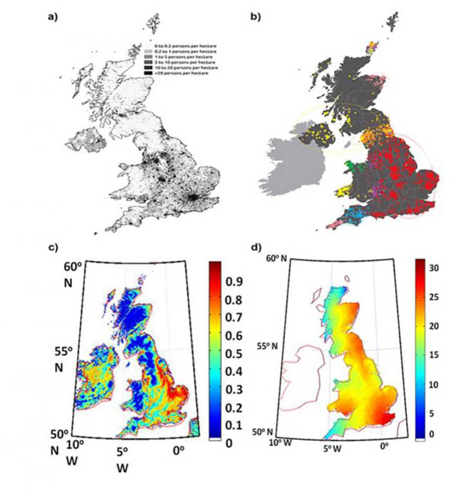
The initial entry points of people into the main British island were determined using data from the megalithic period. Topographical and hydro-shed data from satellite databases was used to define habitability, based on distance from water bodies, flatness of the terrain and altitude above sea level.
Population movement was simulated based on assumptions of affinity for more habitable places, with the rate of movement tempered by existing populations.
The scientists compared the results of their computer simulations with available genetic data to show that their simulation can predict fairly accurately the points of contact between different migratory paths. Such a comparison also provides more detailed information about the path of peoples’ movement over ~2,000 years before the present era.
The article can be found at: Vahia et al. (2016) Population Dynamics of Early Human Migration in Britain.
———
Source: Tata Institute of Fundamental Research; Photo: Mathieu/Flickr/CC.
Disclaimer: This article does not necessarily reflect the views of AsianScientist or its staff.