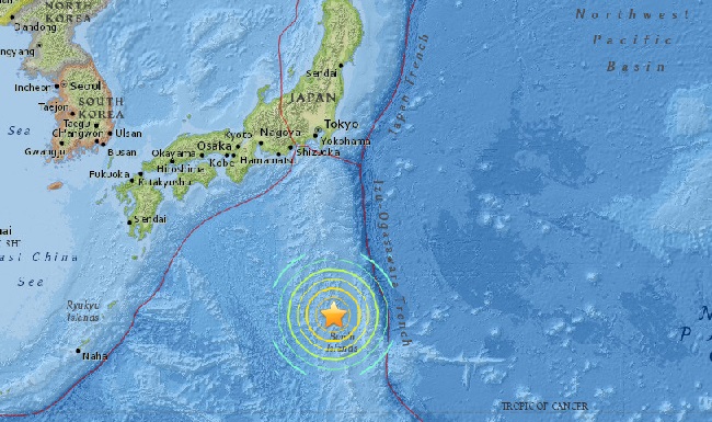

AsianScientist (Dec. 7, 2012) – A powerful 7.3 magnitude earthquake struck the east coast of Japan earlier today at 17:18 JST, triggering a one-meter tsunami at its epicenter.
According to the U.S. Geological Survey (USGS), the geographic location of the earthquake was 37.8°N latitude and 144.1°E longitude, which is approximately 462 km from Tokyo.
The undersea quake took place at an ocean depth of 36.1 km.
A tsunami warning issued by the Japan Meteorological Agency for the Miyagi Prefecture was lifted at 19:20 JST, two hours after the earthquake struck.
Other coastal regions – the Aomori, Iwate, Fukushima, and Ibaraki Prefectures – have also been cleared from the advisory, although the Japanese Meteorological Agency advises residents to pay attention when fishing and swimming as there may still be some sea-level changes in these areas.
Japan sits on four major tectonic plates: the Pacific, North America, Eurasia, and Philippine Sea plate. Subduction zones at the Japanese island arcs are geologically complex and produce numerous earthquakes.
Today’s quake occurred as a result of reverse faulting within the oceanic lithosphere of the Pacific plate, approximately 20 km east of the location where the Pacific subducts beneath Japan.
The same plate boundary region surrounding the December 7 earthquake has hosted 12 large earthquakes of magnitude 7.0 and greater over the past 40 years, including the 9.0 magnitude Tohoku earthquake of March 11, 2011, which spawned a major tsunami and nuclear disaster at the Fukushima Dai-chi nuclear power plant.
Since 1900, three great earthquakes occurred off Japan and three north of Hokkaido. They are the M8.4 1933 Sanriku-oki earthquake, the M8.3 2003 Tokachi-oki earthquake, the M9.0 2011 Tohoku earthquake, the M8.4 1958 Etorofu earthquake, the M8.5 1963 Kuril earthquake, and the M8.3 1994 Shikotan earthquake.
——
Source: USGS; JMA; Photo: NASA Goddard Photo and Video/Flickr/CC.
Disclaimer: This article does not necessarily reflect the views of AsianScientist or its staff.